
File:Ugandan districts affected by Lords Resistance Army.png

Laga ekifaananyi ekijjuvu (pikseli 596 ku 735 , bunene bwa fayiro: KB 92, kika kya MIME: image/png)

|
This military map image could be re-created using vector graphics as an SVG file. This has several advantages; see Commons:Media for cleanup for more information. If an SVG form of this image is available, please upload it and afterwards replace this template with
{{vector version available|new image name}}.
It is recommended to name the SVG file “Ugandan districts affected by Lords Resistance Army.svg”—then the template Vector version available (or Vva) does not need the new image name parameter. |
Summary
Sources used to draw this map
- Maps in USAID/RLP (2004) Refugee Law Project Working Paper No. 11 ( online version)
- IDP Project maps (Uganda, Sudan
- UN Department of Public Information, Map no. 3862.1 (september 2002), Ugandan district boundaries
- Wikipedia article onLRA
- You are free:
- to share – to copy, distribute and transmit the work
- to remix – to adapt the work
- Under the following conditions:
- attribution – You must give appropriate credit, provide a link to the license, and indicate if changes were made. You may do so in any reasonable manner, but not in any way that suggests the licensor endorses you or your use.
This image was created by Mark Dingemanse and released under the Creative Commons Attribution 2.5 license. The image and any derivatives should be attributed to its creator (Mark Dingemanse) and/or to his agency (vormdicht); if you choose the latter, please provide a link to www.vormdicht.nl. Feel free to notify me when you're using one of my images outside of the Wikimedia projects; that way, I'll be able to let you know when I release an updated version.
Ebyafaayo ebya fayiro eno
Bw'onyiga ku nnaku n'essaawa, ojjakulaba fayiro nga bwe yali efaanana ku kiseera ekyo.
| Ennaku n'obudde | Kulingiza | Obuwanvu n'obugazi bwakyo | Eyakiteekawo | Okulw'ogerako | |
|---|---|---|---|---|---|
| oluwandika oluliwo kakano | 17:35, 6 Gwakuna 2012 | | 596 × 735 (KB 92) | Ras67 | cropped |
| 18:08, 20 Gwakusatu 2012 |  | 600 × 739 (KB 91) | Hoshie | Reverted to version as of 00:37, 22 February 2008: The data the map is based on is before S. Sudan succeeded - sorry for the mixup. | |
| 03:21, 9 Gwakusatu 2012 |  | 600 × 739 (KB 142) | Hoshie | updated to include South Sudan; I tried to get the font to match. | |
| 00:37, 22 Gwakubiri 2008 |  | 600 × 739 (KB 91) | Mahahahaneapneap | pngcrushed | |
| 14:10, 29 Gwakkuminebiri 2004 |  | 600 × 739 (KB 97) | M. Dingemanse | new version: few layout fixes, cleaned up superfluous cities, enlarged text | |
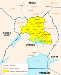
| 22:37, 26 Gwakkuminebiri 2004 |  | 600 × 739 (KB 106) | M. Dingemanse | Ugandan districts affected by Lord's Resistance Army - created by Mark Dingemanse - {{cc-by-2.0}} |
Empapula eziriko enyunzi ezigguka ku kifaananyi kino
Empapula 1 ezikuggusa ku fayiro eno ze:
Global file usage
The following other wikis use this file:
- Usage on af.wikipedia.org
- Usage on be.wikipedia.org
- Usage on de.wikipedia.org
- Usage on en.wikipedia.org
- Lord's Resistance Army insurgency
- Holy Spirit Movement
- Alice Auma
- Portal:Africa/Featured article
- Lord's Resistance Army insurgency (1987–1994)
- Lord's Resistance Army insurgency (1994–2002)
- Template:Lord's Resistance Army
- Lord's Resistance Army insurgency (2002–2005)
- 2006–2008 Juba talks
- Julius Achon
- Portal:Africa/Featured article/5
- Lord's Resistance Army
- 2008–2009 Garamba offensive
- 2008 Christmas massacres
- Makombo massacre
- International Criminal Court investigation in Uganda
- Kony 2012
- User talk:M. Dingemanse/Archive16
- User:Huntersgordon/sandbox
- Refugees of Uganda
- War in Uganda (1986–1994)
- Wikipedia:In the news/Posted/October 2005
- Usage on en.wikinews.org
- Usage on es.wikipedia.org
- Usage on fi.wikipedia.org
- Usage on fr.wikipedia.org
- Usage on fr.wikinews.org
- Usage on hu.wikipedia.org
- Usage on ja.wikipedia.org
- Usage on ko.wikipedia.org
- Usage on pl.wikipedia.org
- Usage on pl.wikinews.org
- Usage on pt.wikipedia.org
View more global usage of this file.