
File:Kentucky counties map.png

Size of this preview: 800 × 387 pixels. Other resolutions: 320 × 155 pixels | 640 × 310 pixels | 1,153 × 558 pixels.
Laga ekifaananyi ekijjuvu (pikseli 1,153 ku 558 , bunene bwa fayiro: KB 112, kika kya MIME: image/png)
Summary
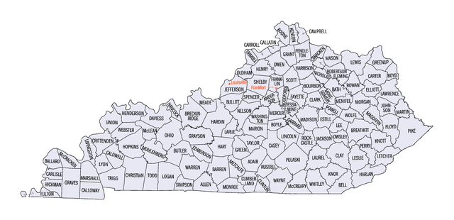
Map of Kentucky counties from http://quickfacts.census.gov/qfd/maps/kentucky_map.html Archived 2013-03-01 at Wikiwix
Licensing
This image or file is a work of a United States Census Bureau employee, taken or made as part of that person's official duties. As a work of the U.S. federal government, the image is in the public domain.
|
 |
Ebyafaayo ebya fayiro eno
Bw'onyiga ku nnaku n'essaawa, ojjakulaba fayiro nga bwe yali efaanana ku kiseera ekyo.
| Ennaku n'obudde | Kulingiza | Obuwanvu n'obugazi bwakyo | Eyakiteekawo | Okulw'ogerako | |
|---|---|---|---|---|---|
| oluwandika oluliwo kakano | 18:36, 17 Gusooka 2009 | | 1,153 × 558 (KB 112) | Nyttend | == Summary == Map of Kentucky counties from http://quickfacts.census.gov/qfd/maps/kentucky_map.html == Licensing == {{PD-USGov-DOC-Census}} Category:Maps of Kentucky <!--{{ImageUpload|basic}}--> |
Empapula eziriko enyunzi ezigguka ku kifaananyi kino
More than 100 pages use this file. The following list shows the first 100 pages that use this file only. A full list is available.
- Adair County, Kentucky
- Allen County, Kentucky
- Anderson County,Kentucky
- Ballard County, Kentucky
- Barren County, Kentucky
- Bath County, Kentucky
- Bell County, Kentucky
- Boone County, Kentucky
- Bourbon County, Kentucky
- Boyd County, Kentucky
- Boyle County, Kentucky
- Bracken County, Kentucky
- Breathitt County, Kentucky
- Breckinridge County, Kentucky
- Bullitt County, Kentucky
- Butler County, Kentucky
- Caldwell County, Kentucky
- Calloway County, Kentucky
- Campbell County, Kentucky
- Carlisle County, Kentucky
- Carroll County, Kentucky
- Carter County, Kentucky
- Casey County, Kentucky
- Christian County, Kentucky
- Clark County, Kentucky
- Clay County, Kentucky
- Clinton County, Kentucky
- Crittenden County, Kentucky
- Cumberland County, Kentucky
- Daviess County, Kentucky
- Edmonson County, Kentucky
- Elliott County, Kentucky
- Estill County, Kentucky
- Fayette County, Kentucky
- Fleming County, Kentucky
- Floyd County, Kentucky
- Franklin County, Kentucky
- Fulton County, Kentucky
- Gallatin County, Kentucky
- Garrard County, Kentucky
- Grant County, Kentucky
- Graves County, Kentucky
- Grayson County, Kentucky
- Green County, Kentucky
- Greenup County, Kentucky
- Hancock County, Kentucky
- Hardin County, Kentucky
- Harlan County, Kentucky
- Harrison County, Kentucky
- Hart County, Kentucky
- Henderson County, Kentucky
- Henry County, Kentucky
- Hickman County, Kentucky
- Hopkins County, Kentucky
- Jackson County, Kentucky
- Jefferson County, Kentucky
- Jessamine County, Kentucky
- Johnson County, Kentucky
- Knott County, Kentucky
- Knox County, Kentucky
- LaRue County, Kentucky
- Laurel County, Kentucky
- Lawrence County, Kentucky
- Leslie County,Kentucky
- Letcher County, Kentucky
- Lewis County, Kentucky
- Lincoln County, Kentucky
- Livingston County, Kentucky
- Logan County, Kentucky
- Lyon County, Kentucky
- Marion County, Kentucky
- Marshall County, Kentucky
- Martin County, Kentucky
- Mason County, Kentucky
- McCracken County, Kentucky
- McCreary County, Kentucky
- Meade County, Kentucky
- Menifee County, Kentucky
- Metcalfe County, Kentucky
- Monroe County, Kentucky
- Nelson County, Kentucky
- Nicholas County, Kentucky
- Ohio County, Kentucky
- Oldham County, Kentucky
- Owen County, Kentucky
- Owsley County, Kentucky
- Perry County, Kentucky
- Pike County, Kentucky
- Robertson County, Kentucky
- Rowan County, Kentucky
- Russell County, Kentucky
- Scott County, Kentucky
- Shelby County, Kentucky
- Simpson County, Kentucky
- Spencer County, Kentucky
- Taylor County, Kentucky
- Wayne County, Kentucky
- Webster County, Kentucky
- Whitley County, Kentucky
- Wolfe County, Kentucky
View more links to this file.
Global file usage
The following other wikis use this file:
- Usage on ar.wikipedia.org
- Usage on cy.wikipedia.org
- Usage on en.wikipedia.org
- List of counties in Kentucky
- National Register of Historic Places listings in Kentucky
- User:TonyTheTiger/List of the Day/Nominees/200803
- Wikipedia:List of the day/March 2008
- Index of Kentucky-related articles
- Outline of Kentucky
- User:Acdixon/Government of Kentucky
- List of metropolitan areas of Kentucky
- Usage on es.wikipedia.org
- Usage on fa.wikipedia.org
- Usage on fr.wikipedia.org
- Usage on he.wikipedia.org
- Usage on hu.wikipedia.org
- Usage on hu.wiktionary.org
- Usage on it.wikipedia.org
- Usage on ja.wikipedia.org
- Usage on ko.wikipedia.org
- Usage on nds.wikipedia.org
- Usage on nl.wikipedia.org
- Usage on pt.wikipedia.org
- Usage on ro.wikipedia.org
- Usage on ru.wikipedia.org
- Usage on simple.wikipedia.org
- Usage on sv.wikipedia.org
- Usage on tum.wikipedia.org
- Kentucky
- Template:Malo (counties) gha Kentucky
- Allen County, Kentucky
- Adair County, Kentucky
- Ballard County, Kentucky
- Barren County, Kentucky
- Carlisle County, Kentucky
- Campbell County, Kentucky
- Calloway County, Kentucky
- Estill County, Kentucky
- Henderson County, Kentucky
- Fleming County, Kentucky
- Franklin County, Kentucky
- Carter County, Kentucky
- Clark County, Kentucky
- Anderson County,Kentucky
- Breathitt County, Kentucky
- Gallatin County, Kentucky
- Boone County, Kentucky
- Bell County, Kentucky
- Bath County, Kentucky
View more global usage of this file.