
File:LanguageMap-Kikongo-Kituba.png

Size of this preview: 800 × 529 pixels. Other resolutions: 320 × 212 pixels | 640 × 423 pixels | 1,024 × 677 pixels | 1,420 × 939 pixels.
Laga ekifaananyi ekijjuvu (pikseli 1,420 ku 939 , bunene bwa fayiro: KB 89, kika kya MIME: image/png)
Summary
| Description |
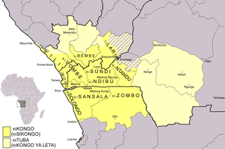
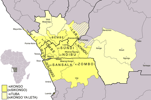
Dialect map of Kikongo. Dark yellow areas are inhabited mainly by first language speakers of the various dialects/languages of Kikongo. Names of some dialects/languages are written on the map. Pale yellow areas are inhabited by first and second language speakers of Kituba (a.k.a. Kikongo ya Leta), which is the lingua franca in the area. Kituba is understood by most speakers of Kikongo. Map drawn by Risto Kupsala. Details are based on the language maps of Ethnologue and several other sources. |
| Date | 2 Gwakuna 2006 (original upload date) |
| Source | No machine-readable source provided. Own work assumed (based on copyright claims). |
| Author | No machine-readable author provided. Rasulo~commonswiki assumed (based on copyright claims). |
Licensing
| I, the copyright holder of this work, release this work into the public domain. This applies worldwide. In some countries this may not be legally possible; if so: I grant anyone the right to use this work for any purpose, without any conditions, unless such conditions are required by law. |
Ebyafaayo ebya fayiro eno
Bw'onyiga ku nnaku n'essaawa, ojjakulaba fayiro nga bwe yali efaanana ku kiseera ekyo.
| Ennaku n'obudde | Kulingiza | Obuwanvu n'obugazi bwakyo | Eyakiteekawo | Okulw'ogerako | |
|---|---|---|---|---|---|
| oluwandika oluliwo kakano | 00:37, 25 Gwakubiri 2021 | | 1,420 × 939 (KB 89) | Somebody040404 | Reverted to version as of 10:10, 29 March 2018 (UTC) |
| 00:26, 25 Gwakubiri 2021 |  | 1,420 × 939 (KB 82) | Somebody040404 | ||
| 10:10, 29 Gwakusatu 2018 |  | 1,420 × 939 (KB 89) | Maphobbyist | South Sudan border | |
| 21:24, 20 Gwakkuminebiri 2007 |  | 1,420 × 939 (KB 60) | Rasulo~commonswiki | Dialect map of Kikongo. Dark yellow areas are inhabited mainly by native speakers of the various dialects/languages of Ki(si)kongo. Names of some dialects/languages are written on the map. Pale yellow areas are inhabited by first and second language speak | |
| 12:12, 22 Gwamusanvu 2006 |  | 718 × 518 (KB 26) | Rasulo~commonswiki | ||
| 09:49, 2 Gwakuna 2006 |  | 571 × 471 (KB 20) | Rasulo~commonswiki | Dialect map of Kikongo Dark green areas are inhabited mainly by first language speakers of the various dialects/languages of Kikongo. Names of some dialects/languages are written on the map. Light green areas are inhabited by first and second language spe |
Empapula eziriko enyunzi ezigguka ku kifaananyi kino
Empapula 1 ezikuggusa ku fayiro eno ze:
Global file usage
The following other wikis use this file:
- Usage on af.wikipedia.org
- Usage on ar.wikipedia.org
- Usage on ast.wikipedia.org
- Usage on az.wiktionary.org
- Usage on bn.wikipedia.org
- Usage on ca.wikipedia.org
- Usage on cs.wikipedia.org
- Usage on da.wikipedia.org
- Usage on de.wikipedia.org
- Usage on en.wikipedia.org
- Usage on eo.wikipedia.org
- Usage on es.wikipedia.org
- Usage on eu.wikipedia.org
- Usage on fi.wikipedia.org
- Usage on frr.wikipedia.org
- Usage on fr.wikipedia.org
View more global usage of this file.